Peregrine-Adventures-iceland_northern-lights-aurora

Nenets Autonomous Okrug - Arctic region of Russia

Nenets Autonomous Okrug

The Nenets National District (NAO) was formed on July 15, 1929 and became the first national district in the Far North of Russia. October 7, 1977 renamed the Nenets Autonomous Okrug. According to the Constitution of the Russian Federation of 1993, the okrug became an equal subject within the Russian Federation. At the same time, the Nenets Autonomous Okrug has a special administrative status - territorially it is part of the Arkhangelsk region, while being a separate subject of the Russian Federation. NAO is part of the North-West Federal District of the Russian Federation.

The territory of the district together with the islands of Kolguev and Vaigach is 176.81 thousand square meters. km (1.05% of the territory of Russia). The district takes the 4th place in the NWFD and the 23rd place in Russia by area.

gerb

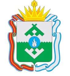
Coat of arms of the Nenets Autonomous Okrug

The emblem of the Nenets Autonomous Okrug symbolizes the state and legal status of the subject of the Russian Federation and reflects the identity and traditions of the Nenets Autonomous Okrug.

The use of three colors in the coat of arms - silver, green and azure - symbolizes the harmony of the three elements: sky (silver), earth (green), water (azure).

Silver symbolizes nobility, frankness, truthfulness. In national symbols, silver also means the North, purity, sincerity and snow. Green indicates the summer tundra; this color is a symbol of hope, abundance and freedom. The azure (blue, blue) color symbolizes the Pechora River, which, according to ancient legends of the peoples living along its banks, connects the world of the living and their ancestors, past and future.

The ornament is made in the form of the Nenets pattern depicting the characteristic features of the traditional way of life of the local population (in the upper part of the composition are the overthrown plague, in the lower part of the composition are deer horns).

In the center of the coat of arms is an image of a flame, which for the Arctic has a special life-affirming value. Fire is a symbol of energy, light, comfort and warmth, which are most valued in the North. The silver flame in the blue circle symbolizes the fire and the natural wealth of the district - oil and gas.

The Golden Land Crown denotes the state status of the Nenets Autonomous Okrug as a subject of the Russian Federation. Order ribbons adorning the coat of arms show the merits of the district, marked by the Order of the Red Banner of Labor (1971) and the Order of Friendship of Peoples (1972).

flag

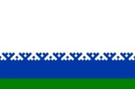
Flag of the Nenets Autonomous Okrug

The flag of the Nenets Autonomous Okrug is a banner with an aspect ratio of 2: 3, divided horizontally into three unequal stripes: white, blue and green.

Above, the blue stripe is limited by an ornament that is traditional in the culture of the peoples of the North. The ornament consists of geometrically regular figures depicted in the form of ordinary (white) and inverted (blue) rafters. Rafters are located at an angle of 90 degrees in relation to each other.

The unit area of ​​the element forming the ornament has a diamond shape and is 1/2500 of the total area of ​​the flag. Each monotonous section of the ornament is repeated along the entire length of the flag eight times and consists of 25 equal rhombs.

The overall height of the blue strip is 1/5 of the width of the panel. The height of the strip of ornament is 2/25 of the width of the panel. The height of the green strip is 3/25 of the width of the banner. "

Geographical position

The Nenets Autonomous Okrug is located in the northeast of the European part of the Russian Federation; most of the district is located beyond the Arctic Circle. The largest length of the district from north to south in the mainland is about 320 km, from west to east - 950 km. The northernmost point of the okrug in the mainland is on Cape Tonky (69 ° 51 'N and 61 ° 10' E), in the island part - on Vaygach Island, Cape Bolvansky Nos (70 ° 27 's N and 58 ° 32 'E).

The Nenets Autonomous Okrug includes the islands of Kolguev, Vaigach, Sensei, Gulyaevsky Cats, Pesyakov, Dolgiy and a number of smaller islands.

The distance from Naryan-Mar to Moscow is 2230 km, to the nearest Pechora railway station - 780 km.

The Nenets Autonomous Okrug borders in the southwest with the Mezen district of the Arkhangelsk region; in the south and southeast - with the Ust-Tsilemsky municipal district and the urban districts of Usinsk, Inta and Vorkuta, related to the Komi Republic; in the east - with the Ural region of the Yamalo-Nenets Autonomous Okrug. In the north, the Nenets Autonomous Okrug has an extended coastline washed by the waters of the White, Barents and Kara Seas of the Arctic Ocean.

Time zone: MSK (UTC + 3, summer UTC + 4)

Climatic conditions

The natural conditions of the okrug are primarily affected by its location in the cold Arctic zone. Two climatic regions are distinguished: the polar (southern part of the okrug's territory) and subarctic (northern and eastern parts). The average temperature in January is from −12 ° C in the southwest to −22 ° C in the northeast; the average temperature in July is from +6 ° C in the north to +13 ° C in the south. Permafrost occupies almost the entire central and northeastern parts of the okrug.

There are up to 100 sunny days a year. Fogs are often observed: from 64 to 100 days a year on the coast and from 37 to 72 days inland.

The Nenets okrug is subject to systematic invasion of Atlantic and Arctic air masses. Frequent change in air masses is the reason for the constant variability of the weather. In winter and autumn, winds with a southern component prevail, and in summer, north and north-east, due to the invasion of cold Arctic air on a heated continent, where atmospheric pressure at this time is lowered.

The entire territory of the district is located in the zone of excessive moisture. Annual precipitation ranges from 400 mm (on the coasts of the seas and Arctic islands) to 700 mm. The minimum rainfall is observed in February, the maximum - in August-September. At least 30% of the precipitation falls in snow.

The average duration of thunderstorms is 10-20 hours per year in the west, east and south of the district. In the north of the district - less than 10 hours a year.

According to wind pressure, the district belongs to the IV district (800 Pa) in the south; V district (1000 Pa) in the northern part; VI district (1250 Pa) on the islands of Kolguev and Vaigach, as well as on the Kanin Peninsula.

By the thickness of the wall of ice, the okrug belongs to the II district (15 mm) in the east and west; III district (20 mm) on the islands of Kolguev, Vaigach and the Kanin Peninsula; District IV on the territory of the Pai Khoi ridge.

Relief:

The main part of the district has a flat relief. Almost 90% of the plains lie within the altitudes of up to 100 meters above sea level; as a result, the district is replete with small lakes (connected by short channels) and swamps (10-20% of the territory). Among the prominent hills are the Timan Ridge and the Pai-Khoi Ridge (height up to 467 m). The main river of the region is Pechora and its tributaries. A characteristic feature of the area is a small proportion of groundwater (less than 5-10% of the water balance of the territory).

In view of the listed natural features, the entire territory of the Nenets Autonomous Area has a vulnerable, extremely sensitive, difficult and slowly recovering ecosystem.